Shelter Island’s ferries weathering storms
Shelter Island has recently alternated from years of drought to monsoon-like rain storms. But North Ferry and South Ferry have managed to weather the storms of late with no need to close down at any point, according to Heights Property Owners Corporation Executive Director Stella Lagudis and South Ferry CEO Cliff Clark.
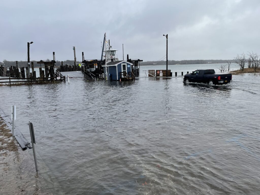
During a stormy day earlier this month, vehicles disembarking on the Shelter Island side of North Ferry encountered difficulty with high water in the terminal roadways. But there was no problem getting boats loaded and unloaded, Ms. Lagudis said.
Small cars, built low to the ground, were asked to wait, and not drive through high water at the South Ferry terminals, Mr. Clark said.
“Kudos go to the crew members,” Ms. Lagudis said.
Also, none of the recent storms caused any threat to the movement of boats crossing between Greenport and Shelter Island or to and from the South Fork.
Constant downpours, strong winds and particularly high tides on Shelter Island over the several days earlier in the month caused widespread flooding. In addition to Bridge Street, other main arteries, such as the causeways, Ram Island Road, and West Neck Road near West Neck Bay, were closed to traffic for a time.

According to a Newsday report, “Greenport Village must make earlier-than-anticipated repairs to the bulkhead in Mitchell Park after an early April nor’easter pummeled the shoreline with torrential rain and whipping winds. The April 3 storm flooded neighborhoods, downed trees and wrecked floating docks in the municipal marina. It also damaged critical points along the wooden bulkhead, leaving gaping holes and cracked concrete in its wake.”
The devastation of the Greenport waterfront is ongoing, not just from recent nor’easters, but from years of heavy weather and rising seas.
Last week, some docks were wrecked along the waterfront.

According to Greenport officials, a federal grant of $3 million will help replace nearly 1,000 feet of bulkhead along Mitchell Park, and the mayor has declared a state of emergency. That federal grant is part of $87 million in funding directed toward Long Island projects.

As for the condition of the increasingly fragile waterfront, as Newsday reported, “The worst of the damage is between the North Ferry landing terminal and Railroad Dock.”
The good news for ferry users now is that the ramp on the Greenport side that had been closed was reopened recently following the completion of work, and a fourth boat is now operational. That leaves one more ramp on the Shelter Island side to be done.
The new ramp on the Greenport side is now 2 feet higher and 6 feet longer, Ms. Lagudis said.
South Ferry wasn’t affected by more recent storms, Mr. Clark said. But the company began investing in lifting and extending docks more than 15 years ago, he said.

Mr. Clark recalled how Super Storm Sandy had him working with his crew to get a patient off the Island to Southampton Hospital and how it took a pickup truck to carry the patient with crew members covering her with a tarp for protection.
He credits his well-trained crew members with the ability to handle any emergencies they’ve encountered to keep the boats running.