County: Consider sea level rise in planning

A resolution adopted by Suffolk County lawmakers last Wednesday will require the Department of Public Works (DPW) to consider the impacts of sea level rise when constructing and reconstructing county roadways.
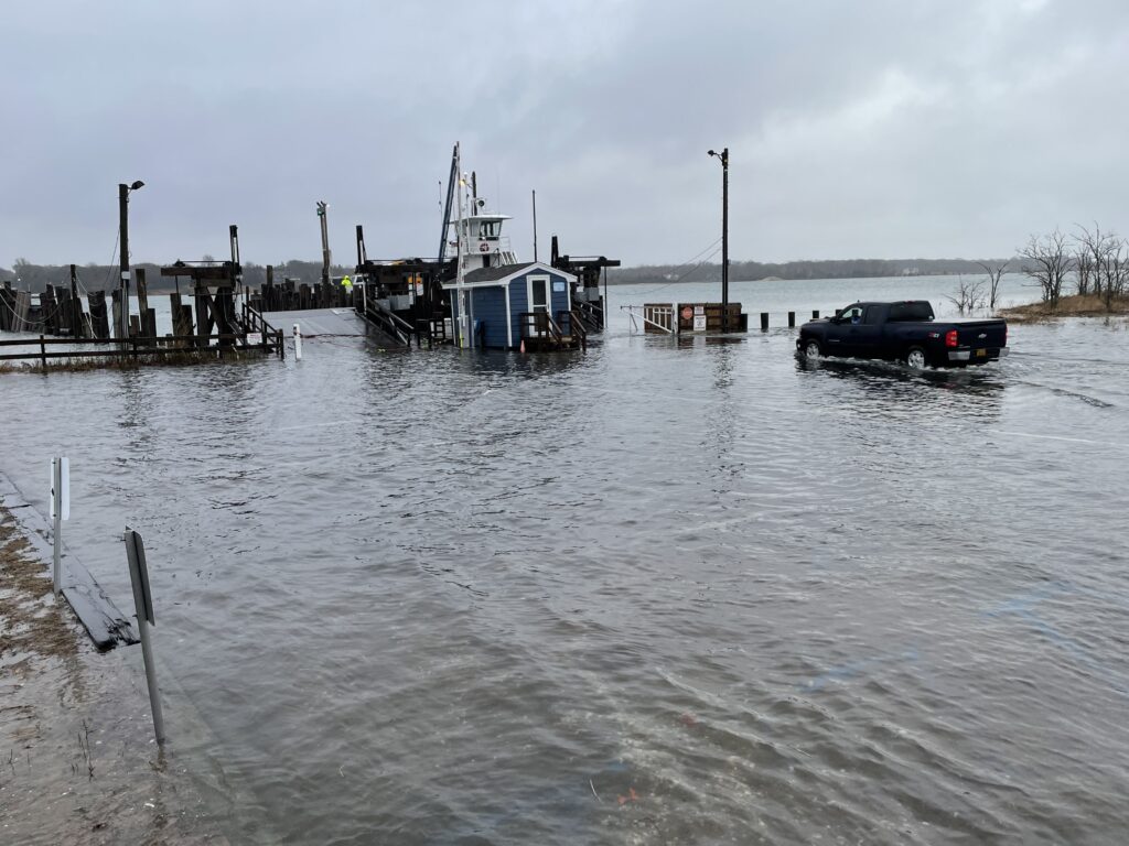
Sea levels are expected to continue to rise at an accelerated rate in the coming years. The New York State Department of Environmental Conservation’s “medium” projections indicate that, since 1900, water levels will have risen six inches by 2020, 16 inches by 2050 and 29 inches by 2080.
Acting DPW Commissioner Darnell Tyson said in a statement earlier this month that the department supports the measure. “[DPW] will continue its efforts to utilize readily available flood map tools to determine how rising sea levels will affect our roadways and bridges,” Mr. Tyson said.
County Legislator Al Krupski (D-Cutchogue), who sponsored the bill, said strengthening infrastructure is one way to respond to climate change. He said instances of “sunny day flooding” during high tides are becoming more prevalent.
“Working with DPW on some of these road projects, it’s pretty obvious what’s happening,” he said. “If you’re going to put in the infrastructure, put it in the right way and it will pay off in a time of high water, because people will be able to get through. It’s a good long-term investment.”
County Legislator Bridget Fleming (D-Noyac), who represents Shelter Island, said she supports “Al’s leadership on this important issue.” Ms. Fleming has been out in front of infrastructure dealing with sea level rises, supporting the fare increase proposed by North Ferry to help pay for bulkheading and raising ramps. She has her own bill in the Legislature on managing capital spending programs to deal with the issue.
Shelter Island Commissioner of Public Works Brian Sherman said there’s about 10 miles of county roads on the Island, many of which were paved last spring. “The county told me that Smith Street, Menantic, West Neck and Shore roads are to be paved this coming spring,” Mr. Sherman said.
A 2017 report published by the National Oceanic and Atmospheric Administration notes that in “regions of the Northeast Atlantic (Virginia coast and northward) and the western Gulf of Mexico coasts, relative sea level rise is projected to be greater than the global average for almost all future global mean sea level rise scenarios.”
In 2010, the New York State Sea Level Rise Task Force issued a report to the Legislature recommending that “long-term plans for maintenance, retrofits and upgrades should incorporate opportunities for adapting existing infrastructure to projected changes in flood risk through elevation, relocation, increased water pumping capacity, or other measures.”
As DPW plans such projects, Peconic Estuary Program Executive Director Joyce Novak suggested they use tools such as the NOAA Sea Level Rise map to overlay various scenarios to influence decision making.
The Peconic Estuary Program is currently finalizing its “Climate Ready Assessment” and “Critical Land Protection Strategy” to help towns identify areas that could become inundated with water in the future. Ms. Novak said the report could be used as a tool for towns to make decisions with regard to planning and land preservation.
Kevin McAllister, founder of the Sag Harbor-based advocacy group Defend H2O, said the legislation is an important reminder for elected officials. “Political decisions made today need to benefit us 30 years out,” he said.